Carl-Viggo Hølmebakk
Jektvik
Jektvik is a small community and a ferry port located on the south side of the fjord in Værangen, Rødøy municipality, on the Helgeland coast.
- Architect:
- Carl-Viggo Hølmebakk
- Finished:
- 2010
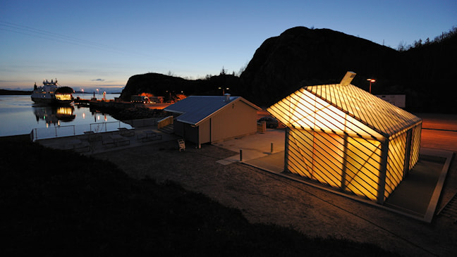
The small service building on the ferry quay at Jektvik is an experiment. In addition to filling some highly pragmatic functions – a waiting room and services – the project mainly focused on transparency and construction, as well as the architectural consequences of these. The service building has a fibreglass skin and an aluminium frame, and internal multi-coloured glass walls. During the dark winter season, the building lights up like an enlarged Chinese lantern to visitors arriving in Jektvik by ferry or car.
Nedre Oscarshaug
Nedre Oscarshaug is a popular spot from which to take photographs of the Hurrungane row of peaks in the Sognefjellet mountains.
- Architect:
- Carl-Viggo Hølmebakk
- Finished:
- 1997
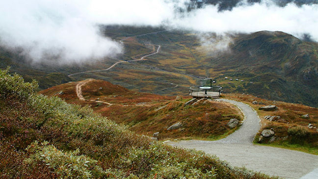
Previously, people would park their cars on the road and trample down the sparse vegetation, hence a more obvious rest area with a car park and an information board was established. At the vantage point, the architect placed a platform near the slope. This entailed only minimal encroachment on the natural environment, while providing visitors with a clear target. A glass plate pointing out the names of all the tallest peaks in the Hurrungane massif was placed in the centre of the platform.
Sohlbergplassen
By placing the foundations on slender pillars, the forest floor could be preserved in near-pristine condition.
- Architect:
- Carl-Viggo Hølmebakk
- Finished:
- 2006
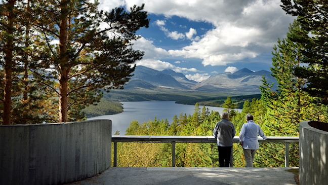
This rest area is located a good kilometre north of the Atnsjø Café, and was already an established vantage point from which the view towards the Atnsjøen lake and the mountains beyond could be admired. Here, Carl-Viggo Hølmebakk wished to create a roadside vantage point that would provide an impression of the Rondane massif evocative of Harald Sohlberg’s painting “Winter Night in the Mountains”. He found that spot near Atnsjøen lake, with a grand and majestic view of the peaks. He clearly saw that to reach this point, visitors had to be raised above ground level, and he constructed a concrete platform that virtually hovers in the air and curves around the slender pine trees. The steel-lattice floor provides water and light to the soft forest floor covered in moss and lichen. The formwork for the concrete was placed between the trees. By placing the foundations on slender pillars, the forest floor could be preserved in near-pristine condition, and only one single tree had to be felled during the construction project.
Strømbu
Strømbu is one of the main gateways to the Rondane massif from the east.
- Architect:
- Carl-Viggo Hølmebakk
- Finished:
- 2008
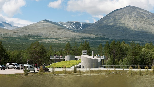
The site is also used as a starting point for hikes in the mountains to the west of Alvdal valley. At Strømbu, we wished to cater to the interests of hikers as well as motorists. The local community in the Atndalen valley took an interest in the planning process at an early stage to establish a staffed kiosk that could serve as an information centre during the tourist season, and this idea was also realized. The main building encompasses an outdoor as well as an indoor area. From the car park, stairs lead up to the roof terrace with a view towards the mountains and the river. Inside, there is an inviting waiting room with a fireplace and benches, from where you can enjoy the scenery and the area around the river through large picture windows. The service facilities are placed in a separate building.
Vegaskjelet
Vegaskjelet has the form of a lay-by where the road turns towards Leirvassbu in the Sognefjellet mountains.
- Architect:
- Carl-Viggo Hølmebakk
- Finished:
- 1996
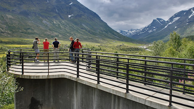
The car park also serves as a turning-place for snow-clearing vehicles during the winter season. In an outline for this stretch, the architect wished to use a standardized concrete platform that could serve a variety of purposes independently of the local topography. At Vegaskjelet, Hølmebakk placed the platform on a concrete foundation protruding horizontally from the car park. This helped raise it above the vegetation that obstructed the view, providing tourists with a better position from which to photograph and experience the landscape. The vantage point is accessible to wheelchair users.
Vøringsfossen
The work on Vøringsfossen has been a lengthy process completed in multiple stages.
- Architect:
- Carl-Viggo Hølmebakk
- Finished:
- 2024
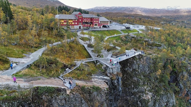
The architectural tender competition that awarded the project to Carl-Viggo Hølmebakk was launched in 2009, the first construction work started in 2015, and in the autumn of 2024, all the planned sub-projects will have been completed.
Vøringsfossen has been a tourist attraction since the early 19th century. It is the river Bjoreio that creates the 182-metre-high waterfall, as it runs from the mountain plateau in the west of Hardangervidda and down into the mighty gorge at the upper end of the Måbødalen valley.
Despite the established position that this place holds within Norwegian tourism, the area has suffered from poor accessibility and inadequate safety. The increasing visitor numbers have also caused significant environmental damage.
Hølmebakk’s ambition for the Vøringsfossen project has been to form clear places and rooms, as architectural responses to the landscape, rather than as a consequence of the landscape.
With this as the main principle, a continuous and safe pedestrian promenade has been designed and built around the entire edge of the gorge, with the waterfall as the central focal point.
The upper area at Fossli and the lower plateau at Fossatromma are connected by the spectacular step bridge over the river Bjoreio above the waterfall and by the old pack road.
The entire facility consists of more than one kilometre of well-secured paths, a number of spectacular viewpoints, large and small bridges, two service buildings and spacious parking areas, one with charging facilities for electric cars.
The project at Vøringsfossen is large and complex, with an unusually close interaction with the site and terrain. Thorough work has been done on registration and measurement, and much of the design has been done at 1:1 scale. With few exceptions, rock blasting has not been necessary, nor has any soil been removed or added beyond what has been required for the sake of paths and drainage.
The geologist demanded that all foundations be pulled in 1.5 metres from the edge of the gorge, a line that in principle also became a material divide. Structures that cantilever towards the gorge are made of prefabricated steel, while foundations, retaining walls and floor surfaces behind the 1.5-metre line are made of concrete, precisely adapted to the terrain.
The paths at Vøringsfossen involve different degrees of construction and facilitation. Some of them are gentle walkways with a high degree of universal accessibility, while others are natural trails in the terrain. The viewpoints are connected to the paths and at each point there is a bench set back from the path, for rest and breaks.
The project has been completed in multiple stages. The first construction stage was carried out in 2015 – 2018 and comprises viewpoints, parking and toilets at Fossli. The second construction stage, including the bridge, paths and toilet facilities at Fossatromma, was completed in 2018-2023.
In the autumn of 2024 the Vøringsfossen project has been supplemented with toilet facilities of the same standard and capacity as those at Fossli.
Contracting client: NPRA