Scenic route Gamle Strynefjellsvegen

Along stone walls and guard stones
The old roadway between east and west is a museum experience in itself. It is a historic alternative to the new trunk road across Strynefjellet Mountain.
Built by manual labour towards the end of the 19th century, this road conveys a historical narrative. The road is an attraction in itself and a testimony to a masterpiece of engineering design from a bygone time.
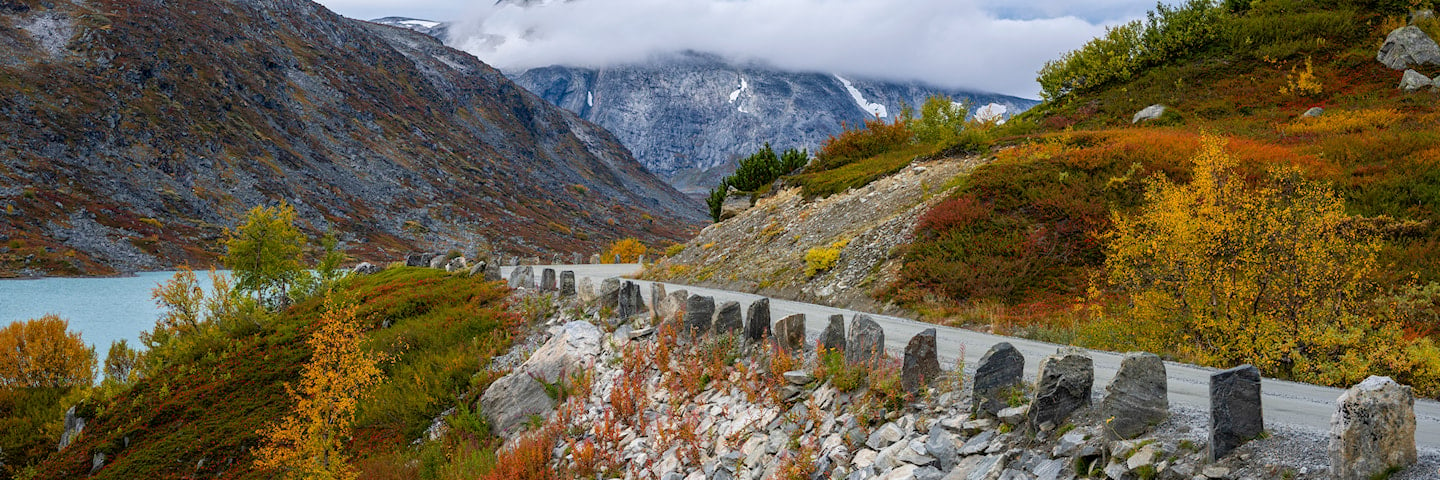
Old hand-built walls of meticulously cut stones and long rows of guard stones characterise the stretch of road across the mountain. The scenic route between Eastern and Western Norway was listed as a protected road in 2009.
Map of the route
Closed for the winter
- Closed:
- Estimated open:
Travel information
- Length
- 27 km
- MASL
- 465 – 1139
Norwegian Scenic Route Gamle Strynefjellsvegen runs between Grotli and Videsæter [258]. The small village of Hjelle also plays an important role in the tourist route since the old road starts at the jetty in Hjelle.
For cyclists: Gamle Strynefjellsvegen is a relatively short route, and we recommend that you start at Grotli. Parts of the route run on gravel roads.
Traffic and road information
Telephone +47 815 48 991
Traffic alerts in map (Norwegian only)
Traffic alerts in telephone app (Norwegian only)
Map information
- GPS, Grotli:
- 62.013444, 7.630327
- GPS, Videsæter:
- 61.937043, 7.264409
Gpx file download for gps and navigation app.
In this file, the direction of travel is from Videsæter to Grotli. Gpx files for all Scenic Routes. Any alternative driving pattern must be adapted by the users themselves.
Information
Emptying toilets from motorhomes and caravans is not permitted in our toilets. The facility is not designed for such use. The nearest dump stations are at Bismo, Lom and Stryn.
Vinterinformasjon
The road has sections closed in winter!
Gamle Strynefjellsvegen is closed in winter. Previous closures are 15 September and 11 October. Previous openings are 15 May and 29 June. NOTE! After opening, the road may be closed for a period at night and in bad weather. Click on the snow icon in the map for information about closures.
Road condition
In places this stretch is narrow with a number of bends and there are restrictions. Vehicles that are more than 8 metres long and have an axle load of more than 8 tonnes will be banned from driving on Gamle Strynefjellsvegen from Grotli to the Vestland county boundary.
-

Photo 1 of 10: Heillstuguvatnet. Photo: Jarle Wæhler, Statens vegvesen -

Photo 2 of 10: Grotli-Videdalen. Norwegian Scenic Route Gamle Strynefjellsvegen. Photo: Jarle Wæhler, Statens vegvesen -

Photo 3 of 10: Vassvendtjønnin, Norwegian Scenic Route Gamle Strynefjellsvegen. Photo: Silja Lena Løken, Statens vegvesen -

Photo 4 of 10: Videdalen. Norwegian Scenic Route Gamle Strynefjellsvegen. Photo: Roger Ellingsen, Statens vegvesen -

Photo 5 of 10: Videfossen. Norwegian Scenic Route Gamle Strynefjellsvegen. Photo: Jarle Wæhler, Statens vegvesen -

Photo 6 of 10: Jøl bru. Photo: Trine Kanter Zerwekh, Statens vegvesen -

Photo 7 of 10: Øvstefossen. Photo: Werner Harstad, Statens vegvesen -

Photo 8 of 10: Hjelledalen. Photo: Helge Stikbakke, Statens vegvesen -

Photo 9 of 10: Segestad. Norwegian Scenic Route Gamle Strynefjellsvegen. Photo: Werner Harstad, Statens vegvesen -

Photo 10 of 10: Hjelle. Norwegian Scenic Route Gamle Strynefjellsvegen. Photo: Werner Harstad
Experiences
When the villages along western fiords began to experience tourism in the last few decades of the 19th century, the idea emerged of a drivable road across Strynefjellet. In 1881, it was therefore decided to build a road. People from Skjåk and surrounding villages, Swedish navvies and construction workers from Gudbrandsdalen worked ten-hour days to complete the road in the period 1889-1894.
Gamle Strynefjellsvegen is a chaussee, typical of its time, with hand-built stonemasonry walls and long rows of guard stones along the road. These formed a roadside guardrail at a time when horses and wagons were more common than cars.
The landscape around the road provides a variety of different hiking options. Walk along the many mountain lakes, follow an old travel route, or let your hike take you to one of the mountain farms in the area. From Gamle Strynefjellsvegen there is a nice drive down to Hjelle, the idyllic village on Lake Strynsvatnet in the valley of Hjelledalen.
Useful links
-
The official travel guide to Norway
-
Travel by bus, train, ferry, metro and plane
-
Good advice for campers
The 18 Norwegian Scenic Routes
Norwegian Scenic Routes are roads that run through unique Norwegian nature. Along the roads you will find artworks, viewpoints and rest areas with innovative architecture in beautiful landscapes.


